
Notice of Proposed Class Action Settlement English
Notice of Proposed Class Action Settlement Korean
Notice of Proposed Class Action Settlement Spanish
_0.jpeg)
Baltimore, MD (June 24, 2025) – Mayor Brandon M. Scott and Department of Transportation (BCDOT) Director Veronica P. McBeth, MSL announced today the relaunch of the Baltimore City Harbormaster Office which will significantly enhance safe access to Baltimore’s iconic waterfront.
“The Baltimore Harbor is the crown jewel of the city, and the relaunch of the Baltimore City Harbormaster Office is a crucial step in making it more accessible and vibrant for everyone," said Mayor Brandon M. Scott. "This initiative will help foster a dynamic waterfront experience that showcases all that our great city has to offer."
The Harbormaster oversees nearly 5,000 linear feet of City-owned docking areas along the waterfront in Baltimore’s Inner Harbor and Fells Point. With competitive rates and an unparalleled location, boaters can enjoy convenient access to Baltimore’s best attractions.
Through the Baltimore City Harbormaster, boaters can use our online Dockwa App to quickly reserve berthing locations. Reservations can be made for docking locations along the Inner Harbor West Wall, Inner Harbor Finger Piers, and portions of Inner Harbor Piers 3, 4, 5 and 6. Boaters can also dock along Broadway Pier, the Thames Bulkhead, and Ann Street Pier in Fells Point. With competitive rates set by the Board of Estimates, recreational boaters can experience why the Inner Harbor is known as the Gateway to the Chesapeake.
“In a city of neighborhoods, the waters of the Inner Harbor serve as a place where we come together to recreate, celebrate, and experience the true charm of Baltimore,” said Director Veronica McBeth. “The Department of Transportation is excited to relaunch the Harbormaster Office which is dedicated to providing a safe and accessible waterfront for all recreational boaters.”
Boaters paying to dock along the Inner Harbor have access to shoreside conveniences at the Baltimore City Harbormaster office located at 400A Key Highway. Amenities include restrooms, showers, coin laundry facilities, WiFi and a boater’s lounge.
The Harbormaster’s modernized operations provide convenient and affordable options for recreational boaters to dock along the Inner Harbor and Fells Point. By moving to the Dockwa online reservation and fee collection system, customer service, safety, and efficiency are significantly improved. Boaters who come to the Inner Harbor without docking reservations can hail the Harbormaster Office on VHF 72 or call 410-396-3174 for assistance.
About Baltimore City Harbormaster:
The Harbormaster is part of Baltimore City’s Department of Transportation and operates under the authority of local and state laws to monitor marine traffic, collect docking fees, encourage compliance with regulations, and maintain safe public access to Baltimore’s Inner Harbor.
Baltimore City Harbormaster information, including docking fees and hours of operation can be found online at: https://transportation.baltimorecity.gov/harbormaster.
###
BALTIMORE, MD (Monday, April 28, 2025) - Today, Mayor Brandon M. Scott and Baltimore City Department of Transportation Director Veronica P. McBeth announced that the Inner Harbor Intersection Improvement Project along Pratt Street will begin in mid-May.
"This intersection improvement project along Pratt Street will contribute to a more accessible and inviting downtown environment that aligns with Baltimore's broader vision for safe urban mobility," said Mayor Scott. "Significant change is happening across downtown - including the reimagining of Harborplace and the investments driven by our Downtown Rise program. To meet this moment, my administration is committed to building a Downtown that is thriving, safe, and prioritizes the pedestrian experience to welcome residents and visitors alike every single day."
The Inner Harbor Intersection Improvement Project will enhance pedestrian safety, accessibility, and overall mobility along Pratt Street by upgrading roadway crossings at key intersections. The project extends along Pratt Street from Light to President Streets, with improvements being done at the intersections of Light, Calvert and President Streets.
Improvements include:
The intersection work is scheduled to begin in mid-May and will require temporary lane closures during construction. These closures will be adjusted to occur at night to minimize disruptions downtown.
"Although it's been a long time coming, we are excited to begin this construction project along Pratt Street that prioritizes pedestrian accessibility in the heart of downtown," said Director McBeth. "This project is designed to upgrade pedestrian infrastructure at the Inner Harbor for an inviting, more navigable urban environment."
This improvement work is expected to last about 9 months. Throughout the project, the city will take into consideration major events occurring downtown in the evenings, including night games at the stadiums, and adjust work schedules accordingly to minimize traffic impacts.
A community meeting will be held at the Baltimore Convention Center on Tuesday, April 29th from 6-8pm to inform project stakeholders, residents and businesses about the project. Additional information about the Inner Harbor Intersection Improvement project along Pratt Street can be found on DOT's Streets of Baltimore website at StreetsofBaltimore.com.
###
The Department of Transportation is welcoming two new administrative employees to our team, including a new Chief Administrative Officer and new Chief of External Affairs.
 Patrick Fleming has joined the agency as BCDOT’s new Chief Administrative Officer. Patrick holds a Master of Science in Law with a concentration in Crisis Management and Homeland Security from the University of Maryland, Baltimore, Francis King Carey School of Law. He also holds a Master of Public Administration from the University of Baltimore and a Bachelor of Science from Towson University. For the last seven years, Patrick has worked in the Emergency Management field. Most recently, he was the Director of Emergency Preparedness in Frederick County, MD.
Previously, Patrick spent over a decade in legislative and policy roles at the State and Local levels with a focus on transportation and education policy. In his new role, he will oversee the Human Resources, Communications, and Data Management teams.
Patrick is an avid Ravens fan, has two pit-mix rescue dogs, and lives with his husband in northern Baltimore City.
 Maureen Kenney has joined BCDOT as the new Chief of External Affairs. Ms. Kenney earned her Bachelor of Arts degree in Journalism and Communications from the University of Massachusetts. She has worked on large capital improvement projects in county, municipal, and regional levels of government including public safety, water infrastructure, wastewater treatment, and mega transportation projects in Maryland and Oregon.
In 2024, Ms. Kenney served as the Acting Communication and Community Engagement Director for the Baltimore Red Line. In this capacity, she helped coalesce a team, build communication infrastructure, and lead the launch of several successful initiatives.
In her new role, Ms. Kenney will oversee the Government Relations and the Community Engagement teams. She resides in Baltimore with her beloved canine companion, a Cardigan Welsh Corgi named Maggie, and enjoys architecture, independent films, live jazz, travel by train and swimming.


We’re honored to share that we received the 2025 Maryland Quality Initiative Award of Excellence in the Modal under $5 Million category for the Martin Luther King Jr. Boulevard at Howard Street Improvements project.
Originally part of the State Center redevelopment, this project moved forward on its own to reconnect neighborhoods through key safety and accessibility upgrades. It included:
We completed the work on time, under budget, and with strong support from the surrounding community. You can watch a full recap of the project here:
https://www.youtube.com/watch?v=KroKhhNHMPA
A huge thank you to the project team:
And appreciation to all our partners who celebrated with us at the awards dinner:
From left to right in the photo: Teri Soos (State Highway Administration), Ravi Nakrani (Civil Construction), Mark Orendorf (Baltimore City Department of Transportation), David F. Young (STV), Michael A. Wilmore (Baltimore City Department of Transportation), Manmohan Singh (Baltimore City Department of Transportation), and Michael Sakata (Maryland Transportation Builders & Materials Association).
This award is a testament to the power of partnership and thoughtful design in creating safer, more connected streets for everyone.

New Special Events and Right of Way Permitting System Changes
The Baltimore City Department of Transportation (BCDOT) is excited to announce that Special Events and Temporary Right of Way Permits will soon be submitted through the OpenGov Permitting System.
The new submittal process is designed to enhance efficiency, improve the user experience, and streamline the permitting process. This updated process will be launched to the public on February 18, 2025.
Key features include:
BCDOT will host a FREE hybrid (in-person and virtual) demo and information session on Thursday, February 13, 2025, from 6:30pm – 8:00pm at 417 E. Fayette Street, 3rd Floor, Baltimore, MD 21202. This session will showcase the system's features and guide users through the application process.
For those who would like to attend the session in person, please register here. The link to attend this session virtually via Webex can be found here. Seating is limited for in-person attendance.
BCDOT encourages permit applicants to attend this session to learn about the exciting changes that will soon be happening with our permit system.

Baltimore, MD (December 9, 2024) – Today, Mayor Brandon M. Scott and Baltimore City Department of Transportation (BCDOT) Director Corren Johnson announced that residents can now report misparked rentable scooters and e-bikes to 311. Once a misparked scooter or e-bike is reported to Lime or Spin through 311 these companies must correct the parking issue within 24 hours. The goal of this initiative is to increase safety for all residents, including those renting vehicles, sharing the sidewalk, and using the road.
The City’s dockless mobility program promotes transportation options for healthier communities and a cleaner environment. So far in 2024, more than 1.4 million trips have been taken on scooters and e-bikes in Baltimore City. Dockless vehicles are a fun and sustainable way to travel; however, at the end of a trip they are sometimes left on the side of the road or found blocking sidewalks and curbs. The correct way to park a scooter or e-bike is to ensure the vehicle is upright and parked in a way that allows pedestrians and those with mobility devices to pass.
The BCDOT is encouraging residents to use the new 311 Service Request to report scooters and e-bikes that are in the way. The new service request is under the category of Parking, Signals and Signs as "Scooter and E-Bike Parking." Scooters and e-bikes that meet one of the conditions below qualify:
311: Parking, Signals and Signs: Scooter and E-Bike Parking:
The GPS pin feature in 311 or an accurately entered address will help companies locate misparked scooters or e-bikes. Additionally, both Spin and Lime offer discounts for users who park correctly in designated corrals that are listed in each of the apps. Damaged scooters or e-bikes should still be reported through the company's app for removal.
Click here to access the micromobility program website if you are in need of addition information.
###
Department of Transportation to Resume Daily Storage Fees for Impounded Vehicles Starting Monday, July 22nd
BALTIMORE, MD (July 18, 2024) – The Baltimore City Department of Transportation (BCDOT) announced today that it will soon resume the assessment of daily storage fees for vehicles impounded at its Pulaski Highway and Fallsway Facilities.
Starting on Monday, July 22, 2024, daily storage fees for impounded vehicles will resume. The resumption of these towing fees coincides with the resumption of late fees on outstanding parking penalties, which was announced in June 2024. These fees were also paused throughout much of the COVID-19 pandemic and their resumption is critical for FY2025, as outlined in this year’s budget process.
Vehicles at the Pulaski Highway or Fallsway facilities that remain impounded after the initial 48 hours will be charged a storage fee of $15 per day for 2-axel vehicles with 4 wheels, including weekends and holidays. Larger vehicles such as dually trucks with six wheels or those with 3 or more axels will be charged a storage fee of $30 per day.
Owners of vehicles that are currently impounded are encouraged to retrieve their vehicles before July 22, 2024, to avoid having daily storage fees assessed. Before vehicles are released, the proper documentation must be provided, including proof of ownership, and verified by BCDOT staff. In addition, all towing and storage fees along with any citations associated with the vehicle must be paid. Please note that towing and storage fees are waived for stolen vehicles with proper documentation.
Motorists are encouraged to call 410-396-9958 to schedule an appointment at the Pulaski Highway facility or click here to visit the Baltimore City, Towing Vehical Recovery Unit for additional information.
###

Mayor Scott, BCDOT Announce Start Date for Expanded Charm City Circulator Service in Cherry Hill Community
New Circulator Route Will Begin Running on June 23, 2024

BALTIMORE, MD (Wednesday, May 22, 2024) – Today, Mayor Brandon M. Scott and Department of Transportation Director Corren Johnson announced expanded service improvements to the Charm City Circulator (CCC), the City of Baltimore’s fare-free bus service providing transit in the downtown area and beyond, will be implemented on June 23, 2024. The service enhancements include a long-anticipated new CCC route, which will serve the Cherry Hill neighborhood, as well as changes to the northern and southern ends of the Purple Route.
The new northern end of the Purple Route extension will connect residents to a hospital system and food hub. The addition of the Cherry Hill Route is a service connection lauded by community and transit advocates as an important step in service equity for Baltimore City. Many residents and businesses alike see the route as an opportunity for enhanced connectivity, greater economic mobility, and a more reliable commute. The expanded network will allow ease of access to job opportunities, entertainment, and all Downtown Baltimore has to offer.
The new Cherry Route will operate between the Inner Harbor and Cherry Hill in southwest Baltimore. Destinations along this new route include Federal Hill, Riverside, McHenry Row, Baltimore Peninsula, Middle Branch Park, MedStar Harbor Hospital, and the Cherry Hill Light Rail Station. Circulator buses along this route will run on a 20-minute frequency.
In addition to the new Cherry Route, the alignment along the Purple Route will be modified. Because the Cherry Route will serve the Federal Hill neighborhood, the Purple Route will no longer travel south of Montgomery Street. Additionally, on the north end of the Purple Route, service will be extended east along 33rd Street to Greenmount Avenue. Additional destinations served along the Purple Route’s new extension include MedStar Union Memorial Hospital and Giant Food.
The Cherry Route will operate on a 20-minute frequency; the Purple Route will operate on a 13-minute frequency; the Orange Route will operate on a 10-minute frequency; the Green Route will operate on a 20-minute frequency; and the Banner Route will operate on a 40-minute frequency.
These service improvements were derived through the Transit Development Plan (TDP) process, which took place throughout 2021 and 2022. The TDP aims to create a roadmap for the Circulator’s future and improve the equity of service. These changes utilize the Circulator’s existing 23-bus fleet and are within the CCC’s existing budget.
The Baltimore City Department of Transportation continues to coordinate with partner agencies and other stakeholders to determine implementation timelines and feasibility of additional changes laid out in the Transit Development Plan.
A service map reflecting the changes that take effect on June 23 is shown below.
###

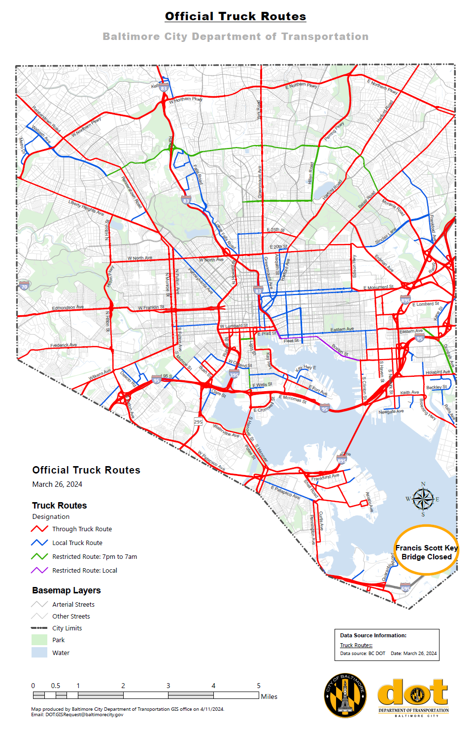
Tuesday, March 26, 2024 - The Baltimore City Department of Transportation has been working closely with local, state, and federal partners since the collapse of the Francis Scott Key Bridge early this morning.
The Baltimore City Department of Transportation is actively evaluating the projected impact of the bridge collapse on City corridors, particularly our designated truck routes. Higher traffic volumes on City roads are anticipated, particularly along designated truck route corridors, and the Baltimore City Department of Transportation is actively working on plans to help mitigate the impact on local communities.
In order to minimize impacts, the Baltimore City Department of Transportation is modifying our official truck map which details how truck drivers may use Baltimore City roads and highways. Please refer to the GIS map for the most up-to-date route information: Baltimore City Official Truck Routes (arcgis.com).
Truckers are encouraged to continue checking this official map in the coming days as additional modifications may be made.
Motorists should also be aware that portions of Fort Armistead Road and Hawkins Point Road are closed at this time. Drivers are encouraged to download the Waze.com app for live detour navigation.

Tuesday, March 26, 2024 - Mayor Brandon M. Scott has officially declared a local State of Emergency in response to the Francis Scott Key Bridge collapse. The Executive Order mobilizes the City of Baltimore’s Emergency Operations Plan to deploy emergency resources to protect the persons affected by the incident and expands the resources available to tackle the emergency situation.
